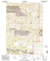
1995 Map of Threemile Buttes
USGS Topo · Published 1998About this map
Custer National Forest lands dominate this mid-1990s terrain, revealing a landscape defined by ranching, water management, and the natural contours of the Powder River region. The survey highlights a dispersed settlement pattern where small-scale infrastructure supports life in this arid geography, anchored by sites like Samuelson Ranch and the Bottlee School. Water is the most critical resource mapped here, evidenced by an extensive network of named springs and small reservoirs such as Ridenour Reservoir and Bobbers Reservoir that dot the draws. The influence of local families and early settlers is preserved through features like Doonan Gulch, Skinner Gulch, and McKennon Spring No 1. While the Sterling Mine indicates localized extractive activity, the map primarily illustrates a working landscape of timber and grazing under federal management, with rugged high points like Threemile Buttes overlooking the drainages of Roundup Creek and Tenmile Creek.
Find a feature on this map
49 named features on this map. Tap any name to fly to it.
Don’t see what you’re looking for? This feature index may not catch every label — zoom into the map to look around manually.
Map Details
Editions of this 1995 Threemile Buttes Map
This is the sole edition of this map. No revisions or reprints were ever made.
Other maps of this area

1954 · Hardin
USGS Topo · 1:250,000

1954 · Ekalaka
USGS Topo · 1:250,000

1956 · Ekalaka
USGS Topo · 1:250,000

1957 · Hardin
USGS Topo · 1:250,000

1958 · Ekalaka
USGS Topo · 1:250,000

1958 · Hardin
USGS Topo · 1:250,000

1965 · Ekalaka
USGS Topo · 1:250,000

1966 · Goodspeed Butte
USGS Topo · 1:24,000

1966 · Sonnette
USGS Topo · 1:24,000

1966 · Coleman Draw
USGS Topo · 1:24,000