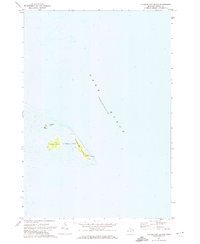
1971 Map of Thunder Bay Island
USGS Topo · Published 1974About this map
Thunder Bay Island and its neighboring landforms rise from the depths of Lake Huron in this detailed hydrographic and topographic study. Located within Alpena Twp, this archipelago is anchored by a historic Lighthouse situated on the southeastern tip of the largest island. The survey captures the intricate shoreline and surrounding shoals of Sugar Island and the smaller Gull Island to the northwest. Because this map incorporates hydrographic data from the U.S. Lake Survey, it provides a rare look at both the terrestrial contours and the submerged bathymetry surrounding these hazards to navigation. The isolation of these features reflects the maritime character of the region in the early 1970s, long a critical point for vessels navigating the Lake Huron shipping lanes.
Find a feature on this map
6 named features on this map. Tap any name to fly to it.
Don’t see what you’re looking for? This feature index may not catch every label — zoom into the map to look around manually.
Map Details
Editions of this 1971 Thunder Bay Island Map
2 editions found
Other maps of this area

1954 · Tawas City
USGS Topo · 1:250,000

1954 · Alpena
USGS Topo · 1:250,000

1957 · Alpena
USGS Topo · 1:250,000

1958 · Alpena
USGS Topo · 1:250,000

1958 · Tawas City
USGS Topo · 1:250,000

1969 · Alpena
USGS Topo · 1:250,000
1971 · Thunder Bay Island
USGS Topo · 1:24,000

1971 · Middle Island
USGS Topo · 1:24,000

1971 · North Point
USGS Topo · 1:24,000
1971 · South Point
USGS Topo · 1:24,000