
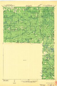
1940 Map of Thunder Mtn.
USGS Topo · Published 1940About this map
The Peshtigo River winds through this 1940 landscape, serving as a central artery for a region defined by its timber heritage and early conservation efforts. This survey captures the transition of the northern Wisconsin woods into a managed recreational and industrial resource, evidenced by the presence of a Lumber Yard and the State Fish Hatchery. The elevation is punctuated by vital forestry infrastructure, including the Thunder Mountain Fire Tower and the Mc Caslin Fire Tower, which provided oversight of the Silver Cliff State Forest.
Find a feature on this map
63 named features on this map. Tap any name to fly to it.
Don’t see what you’re looking for? This feature index may not catch every label — zoom into the map to look around manually.
Map Details
Editions of this 1940 Thunder Mtn. Map
2 editions found
Other maps of this area

1939 · Dunbar
USGS Topo · 1:48,000

1939 · Goodman
USGS Topo · 1:48,000

1939 · Laona
USGS Topo · 1:48,000

1940 · Athelstane
USGS Topo · 1:48,000

1941 · Dunbar
USGS Topo · 1:48,000

1941 · Coleman
USGS Topo · 1:48,000

1942 · Athelstane
USGS Topo · 1:48,000

1942 · Coleman
USGS Topo · 1:48,000

1942 · Breed
USGS Topo · 1:48,000

1942 · Wabeno
USGS Topo · 1:48,000