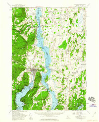
1950 Map of Ticonderoga
USGS Topo · Published 1960About this map
Fort Ticonderoga and the strategic narrows of Lake Champlain anchor this mid-century landscape, illustrating the intersection of military history and early American commerce. The topography reveals the dominant heights of Mt Defiance and Mount Independence, which once dictated colonial defense, while the 1950s infrastructure shows a region defined by transit and industry. The Delaware and Hudson RR and Rutland RR lines trace the shorelines, serving established settlements like Crown Point and Orwell.
Find a feature on this map
143 named features on this map. Tap any name to fly to it.
Don’t see what you’re looking for? This feature index may not catch every label — zoom into the map to look around manually.
Map Details
Editions of this 1950 Ticonderoga Map
3 editions found
Other maps of this area

1893 · Whitehall
USGS Topo · 1:62,500

1894 · Elizabethtown
USGS Topo · 1:62,500

1894 · Port Henry
USGS Topo · 1:62,500

1894 · Ticonderoga
USGS Topo · 1:62,500

1895 · Whitehall
USGS Topo · 1:62,500

1895 · Elizabethtown
USGS Topo · 1:62,500

1895 · Paradox Lake
USGS Topo · 1:62,500

1895 · Castleton
USGS Topo · 1:62,500

1896 · Ticonderoga
USGS Topo · 1:62,500

1897 · Bolton
USGS Topo · 1:62,500