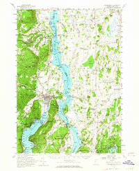
1950 Map of Ticonderoga
USGS Topo · Published 1964About this map
Fort Ticonderoga and its surrounding defenses anchor this mid-century survey of the narrows where Lake Champlain and Lake George converge. The landscape is defined by its military history and early industrial footprints, including the Spar Mine on Breeds Hill and the Fish Hatchery near Crown Point. The map captures a critical transport corridor during a period of transition, showing the Rutland Railroad and Delaware and Hudson lines as they skirt the shores and cross the wetlands of Porters Marsh.
Find a feature on this map
181 named features on this map. Tap any name to fly to it.
Don’t see what you’re looking for? This feature index may not catch every label — zoom into the map to look around manually.
Map Details
Editions of this 1950 Ticonderoga Map
3 editions found
Other maps of this area

1893 · Whitehall
USGS Topo · 1:62,500

1894 · Elizabethtown
USGS Topo · 1:62,500

1894 · Port Henry
USGS Topo · 1:62,500

1894 · Ticonderoga
USGS Topo · 1:62,500

1895 · Whitehall
USGS Topo · 1:62,500

1895 · Elizabethtown
USGS Topo · 1:62,500

1895 · Paradox Lake
USGS Topo · 1:62,500

1895 · Castleton
USGS Topo · 1:62,500

1896 · Ticonderoga
USGS Topo · 1:62,500

1897 · Bolton
USGS Topo · 1:62,500