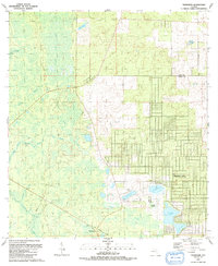
1991 Map of Tidewater
USGS Topo · Published 1991About this map
The low-lying wetlands of western Levy and Marion County dominate this 1991 landscape, where the transition from dense hydric forests to emerging developments is clearly visible. The settlement of Tidewater sits near the southwestern edge, adjacent to the distinct Old Railroad Grade that speaks to the area's earlier timber or transit history. To the east, the geometric street patterns of Rainbow Lakes contrast sharply with the surrounding natural features, signaling late 20th-century residential expansion into the Florida interior.
Find a feature on this map
20 named features on this map. Tap any name to fly to it.
Don’t see what you’re looking for? This feature index may not catch every label — zoom into the map to look around manually.
Map Details
Editions of this 1991 Tidewater Map
This is the sole edition of this map. No revisions or reprints were ever made.
Other maps of this area

1892 · Dunnellon
USGS Topo · 1:62,500

1894 · Dunnellon
USGS Topo · 1:62,500

1895 · Williston
USGS Topo · 1:62,500

1954 · Romeo
USGS Topo · 1:24,000

1954 · Dunnellon
USGS Topo · 1:24,000

1954 · Yankeetown SE
USGS Topo · 1:24,000

1954 · Bronson SW
USGS Topo · 1:24,000

1954 · Dunnellon
USGS Topo · 1:62,500

1954 · Gainesville
USGS Topo · 1:250,000

1955 · Lebanon Station
USGS Topo · 1:24,000