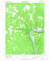
1966 Map of Tidioute
USGS Topo · Published 1968About this map
Tidioute anchors this mid-century topographic survey, situated at a sharp bend in the Allegheny River where Tidioute Creek meets the main channel. The landscape is defined by the heavy presence of the timber and petroleum industries, shown through numerous oil wells and gas wells scattered across the highlands of the Allegheny National Forest. The river itself is punctuated by distinct landmarks like Tidioute Island, Siggis Island, and Courson Island, with Tidioute Eddy and Courson Eddy marking traditional river navigation points.
Find a feature on this map
65 named features on this map. Tap any name to fly to it.
Don’t see what you’re looking for? This feature index may not catch every label — zoom into the map to look around manually.
Map Details
Editions of this 1966 Tidioute Map
4 editions found
Other maps of this area

1926 · Youngsville
USGS Topo · 1:62,500

1927 · Tidioute
USGS Topo · 1:48,000

1927 · Titusville
USGS Topo · 1:62,500

1929 · Corry
USGS Topo · 1:48,000

1929 · Youngsville
USGS Topo · 1:62,500

1930 · Tidioute
USGS Topo · 1:62,500

1932 · Corry
USGS Topo · 1:62,500

1933 · Titusville
USGS Topo · 1:62,500

1943 · Youngsville
USGS Topo · 1:62,500

1957 · Warren
USGS Topo · 1:250,000