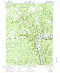
1966 Map of Tidioute
USGS Topo · Published 1984About this map
The Allegheny River carves a deep valley through this Warren County landscape, anchoring the borough of Tidioute along its northern bank. By the mid-1960s, the community remained a central hub for the surrounding plateau, where family-named intersections like Whitehead Corners and McGraw Corners mark the upland road network. The Penn Central railroad follows the river's curve, passing Siggias Island and Courson Island, while the nearby hills are dotted with active oil wells and pipelines, signaling the region’s enduring industrial ties. High elevations such as Morrison Hill and Babylon Hill overlook the river valley, with much of the eastern terrain protected within the Allegheny National Forest and State Game Lands No 86. This survey provides a clear view of the rural settlement patterns before significant modern development, including quiet locations like Fagundus and the Morrison Hill Cem.
Find a feature on this map
44 named features on this map. Tap any name to fly to it.
Don’t see what you’re looking for? This feature index may not catch every label — zoom into the map to look around manually.
Map Details
Editions of this 1966 Tidioute Map
4 editions found
Other maps of this area

1926 · Youngsville
USGS Topo · 1:62,500

1927 · Tidioute
USGS Topo · 1:48,000

1927 · Titusville
USGS Topo · 1:62,500

1929 · Corry
USGS Topo · 1:48,000

1929 · Youngsville
USGS Topo · 1:62,500

1930 · Tidioute
USGS Topo · 1:62,500

1932 · Corry
USGS Topo · 1:62,500

1933 · Titusville
USGS Topo · 1:62,500

1943 · Youngsville
USGS Topo · 1:62,500

1957 · Warren
USGS Topo · 1:250,000