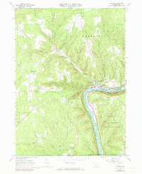
1966 Map of Tidioute
USGS Topo · Published 1973About this map
The Allegheny River carves a deep valley through the center of this terrain, with the borough of Tidioute serving as the primary hub along its northern banks. This 1966 survey, revised in the 1970s, captures a river-oriented economy supported by the Penn Central railroad and the presence of numerous small landings and eddies like Tidioute Eddy and Lower Eddy. The surrounding uplands within the Allegheny National Forest are defined by numerous family-named crossroads and small settlements such as Fagundus, Excelsior Corners, and Whitehead Corners.
Find a feature on this map
59 named features on this map. Tap any name to fly to it.
Don’t see what you’re looking for? This feature index may not catch every label — zoom into the map to look around manually.
Map Details
Editions of this 1966 Tidioute Map
4 editions found
Other maps of this area

1926 · Youngsville
USGS Topo · 1:62,500

1927 · Tidioute
USGS Topo · 1:48,000

1927 · Titusville
USGS Topo · 1:62,500

1929 · Corry
USGS Topo · 1:48,000

1929 · Youngsville
USGS Topo · 1:62,500

1930 · Tidioute
USGS Topo · 1:62,500

1932 · Corry
USGS Topo · 1:62,500

1933 · Titusville
USGS Topo · 1:62,500

1943 · Youngsville
USGS Topo · 1:62,500

1957 · Warren
USGS Topo · 1:250,000