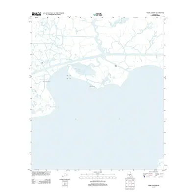
2012 Map of Tigre Lagoon
USGS Topo · Published 2012About this map
Vermilion Bay dominates the southern half of this coastal landscape, meeting the intricate marshland of Iberia Parish at the start of the 2010s. The region is defined by a complex hydraulic network where natural waterways like Bayou Portage and Three Bayou exist alongside industrial cuts such as Oaks Canal and Avery Canal. This intersection of water and land is further shaped by the local energy economy, with the Bayou Hebert Gas Field and South Tigre Lagoon Gas Field marking significant extraction sites within the wetlands. The namesake Tigre Lagoon sits central to this transition, tucked between the larger bay and the inland bayous. To the west, Champlain Point defines the shoreline near the entrance of Bayou Hebert, illustrating a coastline continuously influenced by both tidal action and maritime infrastructure.
Find a feature on this map
11 named features on this map. Tap any name to fly to it.
Don’t see what you’re looking for? This feature index may not catch every label — zoom into the map to look around manually.
Map Details
Editions of this 2012 Tigre Lagoon Map
This is the sole edition of this map. No revisions or reprints were ever made.
Other maps of this area

1932 · Abbeville SE
USGS Topo · 1:31,680

1932 · Abbeville NE
USGS Topo · 1:31,680

1937 · Derouen
USGS Topo · 1:62,500

1945 · New Orleans
USGS Topo · 1:250,000

1946 · Redfish Point NE
USGS Topo · 1:31,680

1948 · Cypremort Point
USGS Topo · 1:24,000

1949 · Cypremort Pt
USGS Topo · 1:31,680

1951 · Cheniere Au Tigre
USGS Topo · 1:62,500
1954 · Redfish Point NE
USGS Topo · 1:31,680

1954 · Port Arthur
USGS Topo · 1:250,000