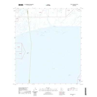
2020 Map of Tigre Lagoon
USGS Topo · Published 2020About this map
Tigre Lagoon and the surrounding marshlands of Iberia Parish define this coastal landscape where the land fragmentates into the expanse of Vermilion Bay. This contemporary survey details the complex hydraulic network of the Louisiana coast, dominated by the heavy commerce of the Intracoastal Waterway and the deep-draft Acadiana Navigation Channel. The interface between the freshwater outflow of Bayou Petite Anse and the brackish bay is documented here, showing the intricate relationship between natural bayous and man-made passages like Avery Canal. While the region is largely defined by open water and wetlands, specific coastal landforms such as Champlain Point and Shark Island remain vital navigational landmarks. The map illustrates the parish line between Iberia and Vermilion, tracing a boundary through a wilderness of marsh and shallow lakes like Lake Cock.
Find a feature on this map
17 named features on this map. Tap any name to fly to it.
Don’t see what you’re looking for? This feature index may not catch every label — zoom into the map to look around manually.
Map Details
Editions of this 2020 Tigre Lagoon Map
This is the sole edition of this map. No revisions or reprints were ever made.
Other maps of this area

1932 · Abbeville SE
USGS Topo · 1:31,680

1932 · Abbeville NE
USGS Topo · 1:31,680

1937 · Derouen
USGS Topo · 1:62,500

1945 · New Orleans
USGS Topo · 1:250,000

1946 · Redfish Point NE
USGS Topo · 1:31,680

1948 · Cypremort Point
USGS Topo · 1:24,000

1949 · Cypremort Pt
USGS Topo · 1:31,680

1951 · Cheniere Au Tigre
USGS Topo · 1:62,500
1954 · Redfish Point NE
USGS Topo · 1:31,680

1954 · Port Arthur
USGS Topo · 1:250,000