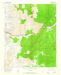
1961 Map of Tijeras
USGS Topo · Published 1962About this map
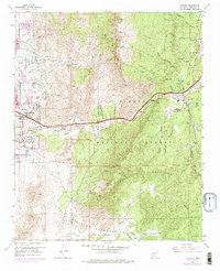
The Sandia Mountains and Manzanita Mountains converge at the gateway to the Canon De Carnue, where this 1961 revision documents the eastern edge of Albuquerque and its mountain hinterlands. The map reveals a landscape defined by the strategic passage of Route 66 through Tijeras Canyon, linking the Rio Grande Valley to settlements like Carnuel, Tijeras, and San Antonio. Local life is anchored by institutions such as the Santo Nino Ch, Santo Nino Cem, and Montoya Sch, while the industrial presence of a large Cement Plant near the canyon floor underscores the era's economic activity. Higher elevations are dominated by the Cibola National Forest, reaching up to South Sandia Peak. The southern portion is notably occupied by the Sandia Military Reservation, illustrating the Cold War-era expansion of government lands adjacent to New Mexico's largest city.
Find a feature on this map
46 named features on this map. Tap any name to fly to it.
Don’t see what you’re looking for? This feature index may not catch every label — zoom into the map to look around manually.
Map Details
Editions of this 1961 Tijeras Map
5 editions found
Other maps of this area

1888 · Bernalillo
USGS Topo · 1:125,000

1889 · Albuquerque
USGS Topo · 1:125,000

1892 · San Pedro
USGS Topo · 1:125,000

1893 · Albuquerque
USGS Topo · 1:125,000

1917 · Estancia
USGS Topo · 1:125,000

1934 · Alameda
USGS Topo · 1:24,000

1934 · East Albuquerque
USGS Topo · 1:24,000

1938 · Albuquerque
USGS Topo · 1:62,500

1952 · Hubbell Spring
USGS Topo · 1:24,000

1954 · Sandia Crest
USGS Topo · 1:24,000
Featured Places
- Albuquerque, NM
- Cedar Crest, NM
- Tijeras, NM
- Vista Del Mundo, Albuquerque
- Winterwood Park (HOA), Albuquerque