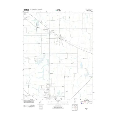
2012 Map of Tilden
USGS Topo · Published 2012About this map
Tilden serves as a central hub in this Southern Illinois landscape, where the town's residential streets meet a network of county roads named for early families and local flora. The map illustrates a region transitioning from its agricultural roots at Flat Prairie toward modern infrastructure, featuring two aviation landmarks: Herschel Hunter Airport and the Sparta Community Airport-Hunter Field. Smaller settlements like Clarmin and Whiteoak are connected by a grid of thoroughfares including Tilden Rd and Marissa Rd.
Find a feature on this map
99 named features on this map. Tap any name to fly to it.
Don’t see what you’re looking for? This feature index may not catch every label — zoom into the map to look around manually.
Map Details
Editions of this 2012 Tilden Map
This is the sole edition of this map. No revisions or reprints were ever made.
Other maps of this area

1910 · Okawville
USGS Topo · 1:62,500

1912 · New Athens
USGS Topo · 1:62,500

1912 · Baldwin
USGS Topo · 1:62,500

1914 · Baldwin
USGS Topo · 1:62,500

1914 · Coulterville
USGS Topo · 1:62,500

1917 · Coulterville
USGS Topo · 1:62,500

1940 · Okawville
USGS Topo · 1:62,500

1942 · Baldwin
USGS Topo · 1:62,500
1954 · New Athens East
USGS Topo · 1:24,000
1954 · New Athens
USGS Topo · 1:62,500