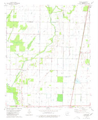
1980 Map of Tilton
USGS Topo · Published 1980About this map
Tilton and the surrounding agricultural lowlands of Woodruff County are defined by a complex network of wetlands and water management features. The landscape is marked by the winding course of Bayou De View and the St Louis Southwestern railroad, which together dictated the settlement patterns of the late 20th century. Local history is anchored by rural centers like Pumpkin Bend and Morton, where the Church of God and Morton Cem serve as long-standing community landmarks. The map documents an intricate hydrology where natural remnants like Old Channel Straight Lake and Little Cow Lake persist alongside the engineered Cow Lake Ditch. This geography highlights the transition from natural bottomlands to an organized grid of farms and irrigation wells, reflecting the era's reliance on both rail transport and water control for regional commerce.
Find a feature on this map
20 named features on this map. Tap any name to fly to it.
Don’t see what you’re looking for? This feature index may not catch every label — zoom into the map to look around manually.
Map Details
Editions of this 1980 Tilton Map
This is the sole edition of this map. No revisions or reprints were ever made.
Other maps of this area

1939 · Vanndale
USGS Topo · 1:62,500

1939 · Wynne
USGS Topo · 1:62,500

1939 · Hunter
USGS Topo · 1:62,500

1940 · Tilton
USGS Topo · 1:62,500

1953 · Memphis
USGS Topo · 1:250,000

1956 · Memphis
USGS Topo · 1:250,000

1956 · Tilton
USGS Topo · 1:62,500

1956 · Hunter
USGS Topo · 1:62,500

1958 · Hunter
USGS Topo · 1:62,500

1958 · Wynne
USGS Topo · 1:62,500