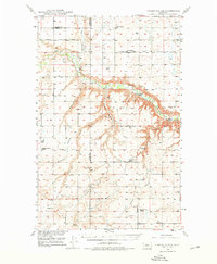
1949 Map of Timber Coulee
USGS Topo · Published 1976About this map
The Teton River meanders through this High Plains landscape, marking a deep incision between the high flats of Chouteau, Teton, and Pondera counties. In the years following World War II, this region remained a patchwork of dryland farming and ranching, evidenced by the distribution of rural civic life. The presence of several one-room schoolhouses, including Aznoe School, Diamond Valley School, Promised Land School, and Pleasant View School, suggests a localized social structure before the consolidation of rural districts. The Jensen Elevator and the Hilltop Silo stand as landmarks of the grain economy, while the Knee Church and a small Cem provide a record of early community centers. Transportation is defined by a network of winding coulees, such as Timber Coulee and Spencer Coulee, and historic routes like the Bootlegger Trail, reflecting a time when river crossings like Woods Crossing Ford and Shannon Bridge were critical nodes for local travel.
Find a feature on this map
29 named features on this map. Tap any name to fly to it.
Don’t see what you’re looking for? This feature index may not catch every label — zoom into the map to look around manually.
Map Details
Editions of this 1949 Timber Coulee Map
2 editions found
Other maps of this area

1886 · Great Falls
USGS Topo · 1:250,000

1920 · Conrad
USGS Topo · 1:125,000

1948 · Portage
USGS Topo · 1:62,500

1949 · Portage
USGS Topo · 1:62,500

1949 · Timber Coulee
USGS Topo · 1:62,500

1949 · Great Falls
USGS Topo · 1:62,500

1949 · Vaughn
USGS Topo · 1:62,500

1950 · Timber Coulee
USGS Topo · 1:62,500

1950 · Dent Bridge
USGS Topo · 1:62,500

1950 · Dutton
USGS Topo · 1:62,500