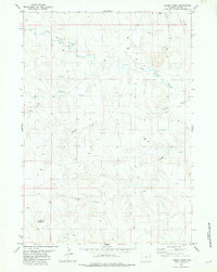
1982 Map of Timber Creek
USGS Topo · Published 1982About this map
Timber Creek flows through the center of this Wyoming-Weston Co. terrain, marking a landscape defined by seasonal drainages and early energy exploration. The map records the network of watercourses including South Beaver Creek and Rough Creek, which carve through the high plains toward the western edge of the Black Hills. Evidence of industrial activity is scattered throughout the township lines, notably with several Drill Hole and Well locations alongside a major Pipeline traversing the northeastern corner. In the southwest, the prominent elevation of Alkali Butte stands as a primary landmark, overlooking the descent into Finn Draw. These details reveal the 1970s-era land use patterns in this remote ranching and resource territory, illustrating the infrastructure required for mineral surveying and water management in the arid West.
Find a feature on this map
9 named features on this map. Tap any name to fly to it.
Don’t see what you’re looking for? This feature index may not catch every label — zoom into the map to look around manually.
Map Details
Editions of this 1982 Timber Creek Map
This is the sole edition of this map. No revisions or reprints were ever made.
Other maps of this area

1899 · Newcastle
USGS Topo · 1:125,000

1901 · Newcastle
USGS Topo · 1:125,000

1951 · Morrisey NE
USGS Topo · 1:24,000

1951 · Osage SE
USGS Topo · 1:24,000

1955 · Newcastle
USGS Topo · 1:250,000

1958 · Newcastle
USGS Topo · 1:250,000
1972 · Klodt Reservoir
USGS Topo · 1:24,000

1979 · Newcastle
USGS Topo · 1:100,000
1982 · Morrisey
USGS Topo · 1:24,000
1982 · Morrisey SE
USGS Topo · 1:24,000