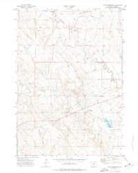
1972 Map of Klodt Reservoir
USGS Topo · Published 1977About this map
The Mush Creek drainage and its surrounding high plains are the focal point of this Weston County survey, conducted in the early 1970s. The landscape is defined by a network of energy infrastructure, where numerous Oil Well locations and Pipeline corridors intersect the natural hydrology. This industrial development is concentrated south of the larger Beaver Creek and across the plains toward the Mush Creek Pumping Sta. In the southeast, the namesake Klodt Reservoir sits along a small tributary, providing a critical water source for the region's ranching or industrial needs. The terrain is marked by distinct topographical features like Sixmile Basin and several named drainages including Slagle Draw, Coyote Draw, and Luce Draw. This map captures a specific moment when the traditional high plains environment was being actively reshaped by oil and gas exploration in the western reaches of the state.
Find a feature on this map
15 named features on this map. Tap any name to fly to it.
Don’t see what you’re looking for? This feature index may not catch every label — zoom into the map to look around manually.
Map Details
Editions of this 1972 Klodt Reservoir Map
This is the sole edition of this map. No revisions or reprints were ever made.
Other maps of this area

1899 · Newcastle
USGS Topo · 1:125,000

1901 · Newcastle
USGS Topo · 1:125,000

1951 · Morrisey NE
USGS Topo · 1:24,000

1951 · Osage SE
USGS Topo · 1:24,000

1955 · Newcastle
USGS Topo · 1:250,000

1958 · Newcastle
USGS Topo · 1:250,000
1972 · Pedro
USGS Topo · 1:24,000
1972 · Osage
USGS Topo · 1:24,000

1979 · Newcastle
USGS Topo · 1:100,000
1982 · Timber Creek
USGS Topo · 1:24,000