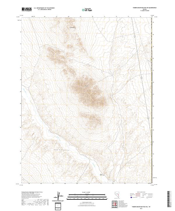
2021 Map of Timber Mountain Pass NE
USGS Topo · Published 2021About this map
White River Valley dominates this high-desert landscape in Nye County, where ephemeral water drainage patterns define the local geography. The map reveals the terminal nature of the regional hydrology at the White River Sink, a point where the intermittent flow of the White River finally disappears into the valley floor. To the north, the sharp elevations of the Gap Mountains and the prominent peak of Fox Mtn overlook the broad basin. This modern 2021 survey illustrates the stark, undeveloped character of this part of the Great Basin, dominated by public land divisions and few permanent human structures, preserving the same remote terrain encountered by early western explorers.
Find a feature on this map
12 named features on this map. Tap any name to fly to it.
Don’t see what you’re looking for? This feature index may not catch every label — zoom into the map to look around manually.
Map Details
Editions of this 2021 Timber Mountain Pass NE Map
This is the sole edition of this map. No revisions or reprints were ever made.
Other maps of this area

1956 · Lund
USGS Topo · 1:250,000

1960 · Lund
USGS Topo · 1:250,000

1969 · Gap Mountain
USGS Topo · 1:24,000

1969 · Hot Creek Butte
USGS Topo · 1:24,000
1971 · Silver King Mtn SW
USGS Topo · 1:24,000
1971 · Timber Mtn Pass NW
USGS Topo · 1:24,000
1971 · Timber Mtn Pass NE
USGS Topo · 1:24,000

1971 · Silver King Mtn
USGS Topo · 1:24,000
1971 · Silver King Well
USGS Topo · 1:24,000
1971 · Timber Mtn Pass East
USGS Topo · 1:24,000