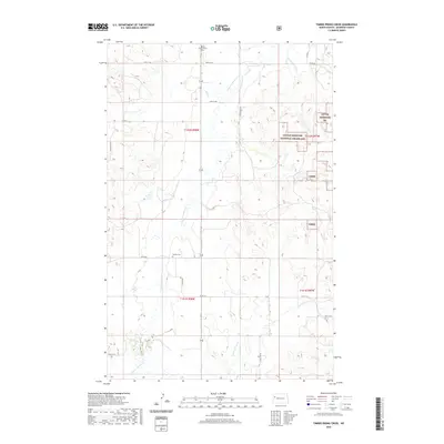
2020 Map of Timber Prong Creek
USGS Topo · Published 2020About this map
Tobacco Garden Cr and Timber Prong Cr carve through the landscape of northwestern North Dakota, defining the drainage patterns in this corner of McKenzie County. This 2020 map documents a region characterized by section-line roads and the expansive acreage of the Little Missouri National Grassland. The presence of Banks Lutheran Cem in the north and Garden Cem near the center provides significant reference points for those researching local family history or the early pastoral settlements of the area. Movement through the territory is facilitated by a network of county roads, including Co Rte 12 and Co Rd 10, which skirt the edges of deep seasonal drainages like Porcupine Coulee. The map serves as a contemporary record of land use and topography in a region where the vast public lands of the Little Missouri NG meet private agricultural sections.
Find a feature on this map
26 named features on this map. Tap any name to fly to it.
Don’t see what you’re looking for? This feature index may not catch every label — zoom into the map to look around manually.
Map Details
Editions of this 2020 Timber Prong Creek Map
This is the sole edition of this map. No revisions or reprints were ever made.
Other maps of this area

1911 · Ray
USGS Topo · 1:125,000

1953 · Williston
USGS Topo · 1:250,000

1953 · Watford City
USGS Topo · 1:250,000

1957 · Williston
USGS Topo · 1:250,000

1957 · Watford City
USGS Topo · 1:250,000

1967 · Watford City
USGS Topo · 1:250,000

1978 · Tobacco Garden Bay
USGS Topo · 1:24,000

1978 · Schafer
USGS Topo · 1:24,000

1978 · Watford City NE
USGS Topo · 1:24,000
1978 · Schafer SE
USGS Topo · 1:24,000