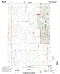
1997 Map of Timber Prong Creek
USGS Topo · Published 2001About this map
Little Missouri National Grassland dominates the eastern edge of this McKenzie County landscape, where the terrain breaks into the complex drainage of Porcupine Coulee. The western portion of the sheet reveals a more settled, agricultural pattern within Twin Valley, defined by a network of local names and community landmarks. Small family settlements and ranching hubs such as Miller, Berquist, and Lundin are scattered along the section lines, while the Townhall and a nearby Airfield mark focal points of local activity in the late 20th century.
Find a feature on this map
32 named features on this map. Tap any name to fly to it.
Don’t see what you’re looking for? This feature index may not catch every label — zoom into the map to look around manually.
Map Details
Editions of this 1997 Timber Prong Creek Map
This is the sole edition of this map. No revisions or reprints were ever made.
Other maps of this area

1911 · Ray
USGS Topo · 1:125,000

1953 · Williston
USGS Topo · 1:250,000

1953 · Watford City
USGS Topo · 1:250,000

1957 · Williston
USGS Topo · 1:250,000

1957 · Watford City
USGS Topo · 1:250,000

1967 · Watford City
USGS Topo · 1:250,000

1978 · Tobacco Garden Bay
USGS Topo · 1:24,000

1978 · Schafer
USGS Topo · 1:24,000

1978 · Watford City NE
USGS Topo · 1:24,000
1978 · Schafer SE
USGS Topo · 1:24,000