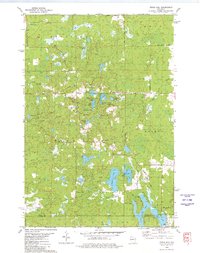
1979 Map of Timms Hill
USGS Topo · Published 1980About this map
Timms Hill, the highest point in Wisconsin, dominates this landscape within the Northwoods of Price and Taylor Counties. The terrain is defined by its glacial history, evidenced by a dense network of kettle lakes including Thirtyfive Lakes, Spirit Lake, and Hultman Lake. Human presence is marked by scattered landmarks like the Garden of Memory Church and its associated cemetery, alongside several hilltop towers used for observation and communication. The map captures the area before modern development significantly altered the timber and recreational character of the township boundaries of Prentice, Hill, and Spirit. Significant waterways like the North Fork Spirit River and Mondeaux Creek drain the surrounding marshes and highlands, while local activity is concentrated near resource sites such as several Gravel Pits and public access points like Spirit Park.
Find a feature on this map
39 named features on this map. Tap any name to fly to it.
Don’t see what you’re looking for? This feature index may not catch every label — zoom into the map to look around manually.
Map Details
Editions of this 1979 Timms Hill Map
2 editions found
Other maps of this area

1941 · Phillips
USGS Topo · 1:48,000

1941 · Brantwood
USGS Topo · 1:48,000

1943 · Philliips
USGS Topo · 1:48,000

1943 · Brantwood
USGS Topo · 1:48,000

1944 · Ogema
USGS Topo · 1:48,000

1945 · Rib Lake
USGS Topo · 1:48,000

1947 · Rib Lake
USGS Topo · 1:48,000

1947 · Ogema
USGS Topo · 1:48,000

1949 · Ogema
USGS Topo · 1:48,000

1949 · Rib Lake
USGS Topo · 1:48,000