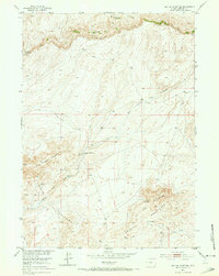
1952 Map of Tin Cup Mountain
USGS Topo · Published 1973About this map
Beaver Rim dominates the northern horizon of this high-altitude Wyoming landscape, where the headwaters of Long Creek and its East Fork carve through the high plains. The area shows a sparse pattern of early development focused on water and minerals, evidenced by the presence of the Tin Cup Mine and the Findlay Reservoir. These water sources, including Findlay Springs and Tin Cup Spring, were critical for the livestock operations and small holdings that characterized the era.
Find a feature on this map
17 named features on this map. Tap any name to fly to it.
Don’t see what you’re looking for? This feature index may not catch every label — zoom into the map to look around manually.
Map Details
Editions of this 1952 Tin Cup Mountain Map
3 editions found
Other maps of this area

1951 · Stampede Meadow
USGS Topo · 1:24,000

1951 · Graham Ranch
USGS Topo · 1:24,000

1951 · Myers Ranch
USGS Topo · 1:24,000

1952 · Tin Cup Mountain
USGS Topo · 1:24,000

1952 · Muskrat Basin
USGS Topo · 1:24,000

1952 · Rongis Reservoir SE
USGS Topo · 1:24,000

1952 · Rongis Reservoir
USGS Topo · 1:24,000

1953 · Blue Gulch
USGS Topo · 1:24,000

1953 · Elkhorn Springs
USGS Topo · 1:24,000

1955 · Lander
USGS Topo · 1:250,000