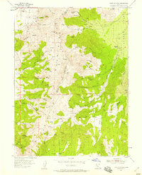
1954 Map of Tintic Mountain
USGS Topo · Published 1958About this map
Sunrise Peak and the high ridges of the Tintic Mountains dominate this mid-century survey along the border of Juab and Utah Counties. The landscape is heavily marked by the region's mining heritage, with a concentration of industrial activity in the northwest corner, including the Buckeye Mine, Rising Sun Mine, and the Evelyn Mine. Further south, the high-altitude Copperopolis site underscores the geological richness that drew prospectors to these slopes. Settlement is sparse, with small outposts like Garbett and the Hancock Ranch located on the eastern fringes where the mountains meet Goshen Valley. The terrain is characterized by deep drainage systems such as Furner Canyon and Birch Creek, which are fed by numerous named water sources like Jumpoff Spring and the curiously named Paul Buoyans Woodpile Springs, essential for the livestock and mining operations of the era.
Find a feature on this map
62 named features on this map. Tap any name to fly to it.
Don’t see what you’re looking for? This feature index may not catch every label — zoom into the map to look around manually.
Map Details
Editions of this 1954 Tintic Mountain Map
3 editions found
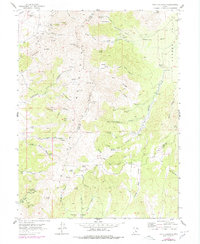
Other maps of this area

1885 · Manti
USGS Topo · 1:250,000

1885 · Sevier Desert
USGS Topo · 1:250,000

1895 · Manti
USGS Topo · 1:250,000

1949 · Eureka
USGS Topo · 1:24,000

1951 · Santaquin
USGS Topo · 1:62,500

1951 · Nephi
USGS Topo · 1:62,500

1953 · Delta
USGS Topo · 1:250,000

1954 · Mc Intyre
USGS Topo · 1:24,000

1954 · Tintic Mountain
USGS Topo · 1:24,000

1954 · Tintic Junction
USGS Topo · 1:24,000