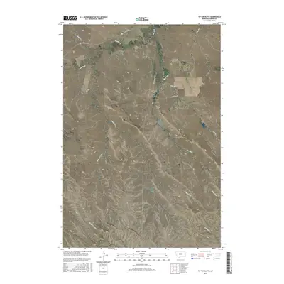
2017 Map of Tip Top Butte
USGS Topo · Published 2017About this map
Tip-Top Butte and Twin Buttes anchor this high-plains landscape in Carter County, where the terrain is defined by a series of prominent points and extensive drainage networks. The northern section is marked by the winding path of Boxelder Cr and the presence of Hammond Rd, which serves as a primary transit corridor through this section of southeastern Montana. The hydrologic pattern is complex, with the Clear Fork and its various tributaries, including Cow Cr and Deep Cr, cutting through the undulating surface. To the south, landmarks such as Wolf Point and Dead Horse Point provide distinct navigational references for those studying the area's topography. The distribution of these named points alongside the Flattops plateau suggests a landscape of significant relief where water sources dictate the traditional movement of people and livestock.
Find a feature on this map
25 named features on this map. Tap any name to fly to it.
Don’t see what you’re looking for? This feature index may not catch every label — zoom into the map to look around manually.
Map Details
Editions of this 2017 Tip Top Butte Map
This is the sole edition of this map. No revisions or reprints were ever made.
Other maps of this area

1954 · Ekalaka
USGS Topo · 1:250,000

1956 · Ekalaka
USGS Topo · 1:250,000

1958 · Ekalaka
USGS Topo · 1:250,000

1965 · Ekalaka
USGS Topo · 1:250,000
1970 · Greasy Hill
USGS Topo · 1:24,000
1981 · Alzada
USGS Topo · 1:100,000
1982 · Black Point NE
USGS Topo · 1:24,000
1982 · Whitetail Creek
USGS Topo · 1:24,000
1982 · Phillippi Reservoir
USGS Topo · 1:24,000
1982 · Potato Buttes
USGS Topo · 1:24,000