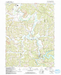
1993 Map of Tippecanoe
USGS Topo · Published 1993About this map
Stillwater Creek winds through the heart of the Harrison and Tuscarawas county line, anchoring a rural landscape defined by narrow valleys and ridge-top settlements. The village of Tippecanoe sits near the southern edge of the sheet, positioned where the creek meets the sprawling waters of Clendening Lake. This 1993 edition, revised from earlier aerial surveys, captures the region's long-standing agricultural and industrial patterns, from the quiet crossroads of Feed Springs to the industrial presence of strip mines and industrial waste ponds near Newport. Local history and genealogy interests are well-represented by several country churches and burial grounds, including Pleasant Grove Ch, Mount Carmel Ch, and the Dutch Valley Cem. The landscape is a network of hollows like Wardell Hollow and Toad Hollow, intersected by an old railroad grade that follows the natural contours of the creek valley.
Find a feature on this map
43 named features on this map. Tap any name to fly to it.
Don’t see what you’re looking for? This feature index may not catch every label — zoom into the map to look around manually.
Map Details
Editions of this 1993 Tippecanoe Map
This is the sole edition of this map. No revisions or reprints were ever made.
Other maps of this area

1902 · Scio
USGS Topo · 1:62,500

1903 · Flushing
USGS Topo · 1:62,500

1904 · Scio
USGS Topo · 1:62,500

1905 · Flushing
USGS Topo · 1:62,500

1909 · Antrim
USGS Topo · 1:48,000

1909 · Uhrichsville
USGS Topo · 1:62,500

1911 · Antrim
USGS Topo · 1:62,500

1911 · Uhrichsville
USGS Topo · 1:62,500

1951 · Canton
USGS Topo · 1:250,000

1953 · Canton
USGS Topo · 1:250,000