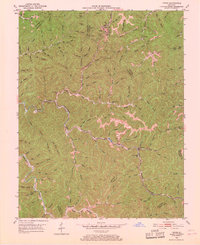
1951 Map of Tiptop
USGS Topo · Published 1968About this map
Tiptop and Evanston anchor this mid-century survey of the Cumberland Plateau's deeply dissected terrain along the border of Breathitt, Magoffin, and Knott Counties. The landscape is defined by an intricate network of narrow hollows and ridges, where life centered on the coal and timber resources accessible via the Chesapeake and Ohio railroad. Numerous strip mines and conveyors are scattered throughout the valleys, particularly around Quicksand Creek, illustrating the industrial intensity of the era.
Find a feature on this map
118 named features on this map. Tap any name to fly to it.
Don’t see what you’re looking for? This feature index may not catch every label — zoom into the map to look around manually.
Map Details
Editions of this 1951 Tiptop Map
4 editions found

Other maps of this area

1886 · Prestonsburg
USGS Topo · 1:125,000

1889 · Salyersville
USGS Topo · 1:125,000

1890 · Whitesburg
USGS Topo · 1:125,000

1891 · Hazard
USGS Topo · 1:125,000

1891 · Salyersville
USGS Topo · 1:125,000

1892 · Whitesburg
USGS Topo · 1:125,000

1892 · Prestonsburg
USGS Topo · 1:125,000

1899 · Salyersville
USGS Topo · 1:125,000

1912 · Hindman
USGS Topo · 1:48,000

1914 · Troublesome
USGS Topo · 1:62,500