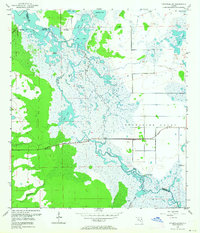
1953 Map of Titusville SW
USGS Topo · Published 1964About this map
Delespine Grant dominates the eastern half of this marshy landscape, where the St Johns River winds through a complex system of shallow lakes and floodplains. Surveyed in the early 1950s, this area at the intersection of Volusia, Brevard, Seminole, and Orange counties highlights a wilderness of cypress and sawgrass before the rapid expansion of neighboring space-age infrastructure. Significant archaeological and natural landmarks like Orange Mound and Paw Paw Mound rise above the wetlands, suggesting long-standing human presence in the river valley. The Cheney Highway provides the primary east-west passage across this watery terrain, passing by a Gaging Station and a Flowing Well as it skirts the edge of Lake Cone. The map documents a labyrinth of water bodies including Loughman Lake, Silver Lake, and South Lake, reflecting the pristine hydrology of the river's upper reaches during this era.
Find a feature on this map
21 named features on this map. Tap any name to fly to it.
Don’t see what you’re looking for? This feature index may not catch every label — zoom into the map to look around manually.
Map Details
Editions of this 1953 Titusville SW Map
5 editions found
Other maps of this area

1949 · Titusville
USGS Topo · 1:24,000

1949 · Mims
USGS Topo · 1:24,000

1949 · Sharpes
USGS Topo · 1:24,000

1950 · Aurantia
USGS Topo · 1:24,000

1951 · Sharpes
USGS Topo · 1:24,000

1952 · Mims
USGS Topo · 1:24,000

1952 · Titusville
USGS Topo · 1:24,000

1953 · Narcoossee NE
USGS Topo · 1:24,000

1953 · Geneva
USGS Topo · 1:24,000

1953 · Titusville SW
USGS Topo · 1:24,000