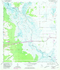
1953 Map of Titusville SW
USGS Topo · Published 1981About this map
The St Johns River winds through a vast expanse of wetlands and lakes at the intersection of Brevard, Volusia, Seminole, and Orange Counties. This area is defined by its complex hydrologic system, where Silver Lake, Loughman Lake, and Ruth Lake feed into the river's main channel. The presence of the Delespine Grant boundary across the eastern marshes reflects early land tenure patterns in this part of Florida.
Find a feature on this map
21 named features on this map. Tap any name to fly to it.
Don’t see what you’re looking for? This feature index may not catch every label — zoom into the map to look around manually.
Map Details
Editions of this 1953 Titusville SW Map
5 editions found
Other maps of this area

1949 · Titusville
USGS Topo · 1:24,000

1949 · Mims
USGS Topo · 1:24,000

1949 · Sharpes
USGS Topo · 1:24,000

1950 · Aurantia
USGS Topo · 1:24,000

1951 · Sharpes
USGS Topo · 1:24,000

1952 · Mims
USGS Topo · 1:24,000

1952 · Titusville
USGS Topo · 1:24,000

1953 · Narcoossee NE
USGS Topo · 1:24,000

1953 · Geneva
USGS Topo · 1:24,000

1953 · Titusville SW
USGS Topo · 1:24,000