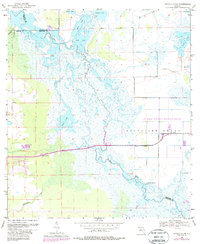
1953 Map of Titusville SW
USGS Topo · Published 1987About this map
The St Johns River winds through a vast network of marshes and lakes in this mid-century survey of the Florida interior. The landscape is defined by its complex hydrology, featuring numerous water bodies such as Loughman Lake, South Lake, and Lake Cone. Near the river's main channel, archaeological and geographical markers like Paw Paw Mound and Bear Island rise above the surrounding wetlands, indicating areas of firmer ground.
Find a feature on this map
23 named features on this map. Tap any name to fly to it.
Don’t see what you’re looking for? This feature index may not catch every label — zoom into the map to look around manually.
Map Details
Editions of this 1953 Titusville SW Map
5 editions found
Other maps of this area

1949 · Titusville
USGS Topo · 1:24,000

1949 · Mims
USGS Topo · 1:24,000

1949 · Sharpes
USGS Topo · 1:24,000

1950 · Aurantia
USGS Topo · 1:24,000

1951 · Sharpes
USGS Topo · 1:24,000

1952 · Mims
USGS Topo · 1:24,000

1952 · Titusville
USGS Topo · 1:24,000

1953 · Narcoossee NE
USGS Topo · 1:24,000

1953 · Geneva
USGS Topo · 1:24,000

1953 · Titusville SW
USGS Topo · 1:24,000