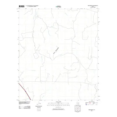
2010 Map of Tobe Branch
USGS Topo · Published 2010About this map
The Blue Mountains dominate the central landscape of this Kimble County region, serving as a primary watershed for the surrounding network of intermittent streams. The drainage pattern here is highly defined by the three branches of Sycamore Creek—West Sycamore Creek, Middle Sycamore Creek, and East Sycamore Creek—which converge as they flow southward toward the main channel of Sycamore Creek. These watercourses, along with Joy Creek and Cedar Creek, illustrate the complex erosion patterns typical of the Edwards Plateau. Local land use is evidenced by a sparse network of roads and trails that navigate the high ground and creek crossings, connecting remote points like Tobe Spring and the drainage of Tobe Branch. The geography captured here reflects a traditional Texas ranching landscape where water sources and topographic barriers dictated the placement of early routes and property boundaries.
Find a feature on this map
9 named features on this map. Tap any name to fly to it.
Don’t see what you’re looking for? This feature index may not catch every label — zoom into the map to look around manually.
Map Details
Editions of this 2010 Tobe Branch Map
This is the sole edition of this map. No revisions or reprints were ever made.
Other maps of this area

1887 · Mason
USGS Topo · 1:125,000

1894 · Mason
USGS Topo · 1:125,000

1894 · Kerrville
USGS Topo · 1:125,000

1954 · Llano
USGS Topo · 1:250,000

1955 · Llano
USGS Topo · 1:250,000

1956 · Llano
USGS Topo · 1:250,000

1968 · Monument Mountain
USGS Topo · 1:24,000

1968 · Yates
USGS Topo · 1:24,000
1970 · Big Draw
USGS Topo · 1:24,000
1974 · Noxville
USGS Topo · 1:24,000