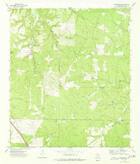
1974 Map of Tobe Branch
USGS Topo · Published 1977About this map
The Blue Mountains dominate the central landscape of this Kimble County terrain, where a complex network of seasonal drainages feeds the headwaters of the Llano River system. The confluence of West Sycamore Creek, Middle Sycamore Creek, and East Sycamore Creek illustrates the intricate dissection of the Edwards Plateau. Human imprint is sparse but functional, centered on ranching infrastructure and local transit routes like the Noxville Road in the south. Notable local landmarks include Tobe Spring and several named draws such as Jim Little Draw, which reflect the essential role of water sources in this semi-arid environment. Scattered throughout the hills are various Gravel Pits and a prominent Radio Tower, marking the technological and industrial activity of the mid-1970s.
Find a feature on this map
19 named features on this map. Tap any name to fly to it.
Don’t see what you’re looking for? This feature index may not catch every label — zoom into the map to look around manually.
Map Details
Editions of this 1974 Tobe Branch Map
This is the sole edition of this map. No revisions or reprints were ever made.
Other maps of this area

1887 · Mason
USGS Topo · 1:125,000

1894 · Mason
USGS Topo · 1:125,000

1894 · Kerrville
USGS Topo · 1:125,000

1954 · Llano
USGS Topo · 1:250,000

1955 · Llano
USGS Topo · 1:250,000

1956 · Llano
USGS Topo · 1:250,000

1968 · Monument Mountain
USGS Topo · 1:24,000

1968 · Yates
USGS Topo · 1:24,000
1970 · Big Draw
USGS Topo · 1:24,000
1974 · Noxville
USGS Topo · 1:24,000