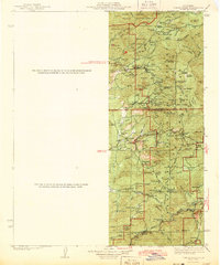
1943 Map of Tobias Peak
USGS Topo · Published 1943About this map
The Tule River Indian Reservation occupies the northern reaches of this territory, where the terrain transitions from the high meadows of the Sierra Nevada down toward the deep canyons of the Kern River. During the early 1940s, this region supported a diverse economy of mountain ranching at Pettitt Ranch, mining operations like the Lone Star Mine, and seasonal tourism at California Hot Sprs. The map captures a landscape defined by small, remote settlements such as Havilah and Keysville, which were once thriving centers of local industry.
Find a feature on this map
105 named features on this map. Tap any name to fly to it.
Don’t see what you’re looking for? This feature index may not catch every label — zoom into the map to look around manually.
Map Details
Editions of this 1943 Tobias Peak Map
2 editions found

Other maps of this area

1904 · Kaweah
USGS Topo · 1:125,000

1905 · Olancha
USGS Topo · 1:125,000

1905 · Fairview
USGS Topo · 1:24,000

1906 · Bakersfield
USGS Topo · 1:62,500

1906 · Kernville
USGS Topo · 1:125,000

1907 · Olancha
USGS Topo · 1:125,000

1908 · Kernville
USGS Topo · 1:125,000

1909 · Kaweah
USGS Topo · 1:125,000

1910 · Buena Vista Lake
USGS Topo · 1:125,000

1912 · Buena Vista Lake
USGS Topo · 1:125,000
Featured Places
- Lackey Place, CA
- Shirley Meadows, CA
- Guernsey Mill, CA
- Johnsondale, CA
- Spear Creek Summer Home Tract, CA