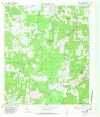
1982 Map of Todd City
USGS Topo · Published 1982About this map
The Neches River flows through this East Texas landscape, forming a natural boundary between Anderson Co and Cherokee Co. The regional economy of the early 1980s is clearly defined by the Todd City Oil Field and the Neches Gas Plant, with numerous oil wells and pipelines marking the wooded terrain. Settlement patterns follow the Missouri Pacific railroad corridor, where the communities of Ironton and Prices are situated. Local genealogy is anchored by several country churches, including Evan Spring Ch, Friendship Ch, and Brushy Chapel, along with the Miller Cem near the northern edge of the map. Distinctive topographic landmarks like Cary Lake Mountain and Tater Hill rise above the river valley, while numerous small lakes such as Hurricane Lake and Cherry Tree Lake dot the wetlands surrounding the river.
Find a feature on this map
38 named features on this map. Tap any name to fly to it.
Don’t see what you’re looking for? This feature index may not catch every label — zoom into the map to look around manually.
Map Details
Editions of this 1982 Todd City Map
This is the sole edition of this map. No revisions or reprints were ever made.
Other maps of this area

1946 · Bullard
USGS Topo · 1:62,500

1948 · Bullard
USGS Topo · 1:62,500

1949 · Palestine
USGS Topo · 1:62,500

1949 · Frankston
USGS Topo · 1:62,500

1950 · Palestine
USGS Topo · 1:62,500

1950 · Frankston
USGS Topo · 1:62,500

1951 · Jacksonville
USGS Topo · 1:62,500

1953 · Palestine
USGS Topo · 1:250,000

1956 · Tyler
USGS Topo · 1:250,000

1957 · Palestine
USGS Topo · 1:250,000