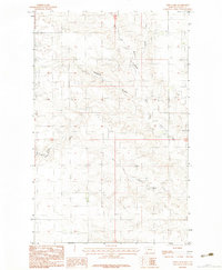
1983 Map of Todd Lakes
USGS Topo · Published 1983About this map
The Todd Lakes define this section of Valley County, where the plains are etched by an intricate network of drainage channels. This 1983 provisional survey highlights the confluence of Wolf Creek and its many tributaries, illustrating the water-management and cattle-grazing landscape of the Fort Peck Indian Reservation. Significant drainage features like Thiessen Coulee and Tree Coulee cut through the terrain, joining the West Fork and Dry Fork Wolf Creek as they flow toward larger basins. The map captures the area as it was recorded during late-1970s field checks, showcasing a sparsely populated ranching environment where the movement of water across the northern Montana prairie dictates the layout of the few unimproved roads and property boundaries.
Find a feature on this map
8 named features on this map. Tap any name to fly to it.
Don’t see what you’re looking for? This feature index may not catch every label — zoom into the map to look around manually.
Map Details
Editions of this 1983 Todd Lakes Map
2 editions found
Other maps of this area

1910 · Todd Lakes
USGS Topo · 1:62,500

1915 · Frazer
USGS Topo · 1:62,500

1915 · Oswego
USGS Topo · 1:62,500

1915 · Todd Lakes
USGS Topo · 1:62,500

1915 · Spring Creek
USGS Topo · 1:62,500

1954 · Wolf Point
USGS Topo · 1:250,000

1954 · Glasgow
USGS Topo · 1:250,000

1957 · Glasgow
USGS Topo · 1:250,000

1958 · Wolf Point
USGS Topo · 1:250,000

1958 · Glasgow
USGS Topo · 1:250,000