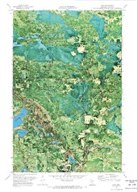
1970 Map of Togo
USGS Topo · Published 1973About this map
The dense woodlands of George Washington State Forest dominate this orthophotomap, which utilizes 1969 aerial photography to provide a clear view of the north-central Minnesota landscape at the turn of the 1970s. The settlement of Togo sits near the eastern edge of the quadrangle, serving as a hub for the surrounding logging and conservation area. Evidence of public infrastructure and social history is visible at the Townhall and the Department of Corrections Youth Camp No 1 situated near the shores of Moose Lake.
Find a feature on this map
17 named features on this map. Tap any name to fly to it.
Don’t see what you’re looking for? This feature index may not catch every label — zoom into the map to look around manually.
Map Details
Editions of this 1970 Togo Map
This is the sole edition of this map. No revisions or reprints were ever made.
Other maps of this area

1919 · Release
USGS Topo · 1:62,500

1943 · Release
USGS Topo · 1:62,500

1954 · Hibbing
USGS Topo · 1:250,000

1957 · Hibbing
USGS Topo · 1:250,000

1958 · Hibbing
USGS Topo · 1:250,000

1964 · Hibbing
USGS Topo · 1:250,000

1964 · Side Lake
USGS Topo · 1:24,000

1964 · Sherry Lake
USGS Topo · 1:24,000

1970 · Rauch
USGS Topo · 1:24,000

1970 · Deer Lake East
USGS Topo · 1:24,000