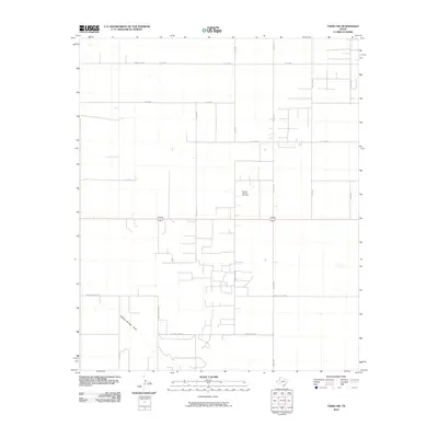
2010 Map of Tokio NW
USGS Topo · Published 2010About this map
The Prentice Oil and Gas Field dominates the landscape of this Yoakum County region, reflecting the industrial character of the Llano Estacado. The terrain is defined by a rigid grid of rural county roads such as Poindexter Rd, Gilliam Rd, and Taylor Rd, which serve the petroleum infrastructure and scattered homesteads. Natural drainage is represented by the Sulphur Springs Draw, which cuts diagonally across the southwestern corner of the quadrangle. Local family and place names are preserved in the road network, including the Ownby Loop Rd, S Ownby Loop Rd, and Morris Lowe Rd N, providing specific points of reference for genealogical research and land-use studies in this portion of West Texas.
Find a feature on this map
18 named features on this map. Tap any name to fly to it.
Don’t see what you’re looking for? This feature index may not catch every label — zoom into the map to look around manually.
Map Details
Editions of this 2010 Tokio NW Map
This is the sole edition of this map. No revisions or reprints were ever made.
Other maps of this area

1954 · Brownfield
USGS Topo · 1:250,000

1958 · Brownfield
USGS Topo · 1:250,000

1962 · Brownfield
USGS Topo · 1:250,000

1969 · Plains 1 SE
USGS Topo · 1:24,000

1970 · Plains 1 SW
USGS Topo · 1:24,000

1970 · Tokio
USGS Topo · 1:24,000

1970 · Tokio NW
USGS Topo · 1:24,000
1970 · Tokio SE
USGS Topo · 1:24,000

1970 · Pleasant Hill
USGS Topo · 1:24,000
1971 · Plains SE
USGS Topo · 1:24,000