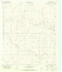
1970 Map of Plains 1 SW
USGS Topo · Published 1973About this map
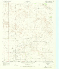
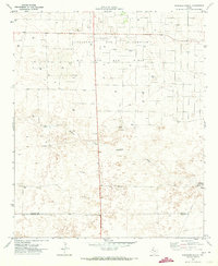
Lost Draw meanders across this Yoakum County landscape, defining the topography of an era when water and oil drove the local economy. Recorded just before 1970, the map illustrates the transition of the West Texas plains into an industrial energy and ranching corridor. The Williams Ranch stands as a primary landmark in a territory otherwise dominated by extractive operations and infrastructure. Numerous Oil Wells and clusters of Drill Holes are scattered across the terrain, indicating the intensity of petroleum exploration during this period. The presence of a Pumping Sta and a high-pressure Pipeline underscores the region's role as a vital energy artery, while a network of Jeep Trails provides the primary access through the open country between established water sources and industrial sites.
Find a feature on this map
11 named features on this map. Tap any name to fly to it.
Don’t see what you’re looking for? This feature index may not catch every label — zoom into the map to look around manually.
Map Details
Editions of this 1970 Plains 1 SW Map
3 editions found
Other maps of this area

1954 · Brownfield
USGS Topo · 1:250,000

1958 · Brownfield
USGS Topo · 1:250,000

1962 · Brownfield
USGS Topo · 1:250,000
1965 · Plains 1 NE
USGS Topo · 1:24,000
1969 · Plains 1 SE
USGS Topo · 1:24,000
1970 · Tokio
USGS Topo · 1:24,000
1970 · Tokio NW
USGS Topo · 1:24,000
1970 · Plains 1 NW
USGS Topo · 1:24,000
1971 · Schooler Ranch
USGS Topo · 1:24,000
1971 · Plains
USGS Topo · 1:24,000