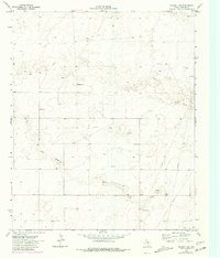
1970 Map of Plains 1 SW
USGS Topo · Published 1981About this map
Lost Draw meanders across this High Plains landscape, marking a prominent natural drainage through the Llano Estacado. The 1970 field check reveals a terrain heavily influenced by the mid-century petroleum and resource extraction industries, characterized by a network of pipelines, numerous oil wells, and drill holes scattered across the flats. While the area is largely rural, the presence of Williams Ranch provides a specific point of reference for genealogical or local land-use research in this corner of Yoakum County. Industrial activity is further evidenced by several gravel pits and a pumping station, all linked by a series of primitive jeep trails that cut across the section lines. These layers of data, including purple revisions from 1979 aerial photography, document the evolving infrastructure of the Texas Panhandle during a period of sustained energy development.
Find a feature on this map
11 named features on this map. Tap any name to fly to it.
Don’t see what you’re looking for? This feature index may not catch every label — zoom into the map to look around manually.
Map Details
Editions of this 1970 Plains 1 SW Map
3 editions found
Other maps of this area

1954 · Brownfield
USGS Topo · 1:250,000

1958 · Brownfield
USGS Topo · 1:250,000

1962 · Brownfield
USGS Topo · 1:250,000

1965 · Plains 1 NE
USGS Topo · 1:24,000

1969 · Plains 1 SE
USGS Topo · 1:24,000

1970 · Plains 1 SW
USGS Topo · 1:24,000

1970 · Tokio
USGS Topo · 1:24,000

1970 · Tokio NW
USGS Topo · 1:24,000

1970 · Plains 1 NW
USGS Topo · 1:24,000

1971 · Schooler Ranch
USGS Topo · 1:24,000