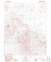
1986 Map of Tolicha Peak
USGS Topo · Published 1986About this map
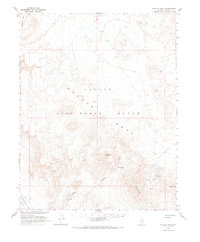
Pahute Mesa and the surrounding high desert terrain define this mid-1980s survey of the northern Nellis Air Force Range (Restricted Area). The landscape is a mix of natural volcanic features and modern military infrastructure, with significant heights including Tolicha Peak and the dark slopes of Obsidian Butte. For those interested in the area's older history, evidence of mineral exploration remains in the numerous prospects, a mine shaft, and several adits clustered near Quartz Mountain. Water is notably scarce, marked only by the seasonal Tolicha Wash and the essential Monte Cristo Spring. The map documents a specialized landscape where natural volcanic landmarks like Fac Hill coexist with a network of aviation-related features, including a Radio Tower, a Blank Pad, and various numbered targets such as Sap 3 through Sap 9 scattered across the flats.
Find a feature on this map
29 named features on this map. Tap any name to fly to it.
Don’t see what you’re looking for? This feature index may not catch every label — zoom into the map to look around manually.
Map Details
Editions of this 1986 Tolicha Peak Map
This is the sole edition of this map. No revisions or reprints were ever made.
Other maps of this area

1908 · Kawich
USGS Topo · 1:250,000

1942 · Tolicha Peak
USGS Topo · 1:125,000
1952 · Black Mtn
USGS Topo · 1:62,500

1954 · Goldfield
USGS Topo · 1:250,000

1955 · Goldfield
USGS Topo · 1:250,000

1958 · Goldfield
USGS Topo · 1:250,000

1962 · Goldfield
USGS Topo · 1:250,000
1966 · Springdale
USGS Topo · 1:62,500
1966 · Thirsty Canyon
USGS Topo · 1:62,500
1968 · Tolicha Peak
USGS Topo · 1:62,500