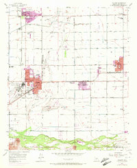
1957 Map of Tolleson
USGS Topo · Published 1972About this map
The Agua Fria River cuts south through this desert landscape toward its confluence with the Gila River near Monument Hill. During the mid-twentieth century, this region saw significant development tied to the Southern Pacific railroad and the expansion of irrigated agriculture via the Southern Canal and Airline Canal. Settlements like Litchfield Park, Goodyear, Avondale, and Tolleson show the early footprints of their modern suburban forms, including local landmarks like the Wigwam Country Club and the Agua Fria Union H S.
Find a feature on this map
61 named features on this map. Tap any name to fly to it.
Don’t see what you’re looking for? This feature index may not catch every label — zoom into the map to look around manually.
Map Details
Editions of this 1957 Tolleson Map
5 editions found

Other maps of this area

1912 · Phoenix
USGS Topo · 1:62,500

1914 · Phoenix
USGS Topo · 1:62,500

1946 · Avondale
USGS Topo · 1:62,500

1948 · Cashion
USGS Topo · 1:62,500

1952 · Laveen
USGS Topo · 1:24,000

1952 · Fowler
USGS Topo · 1:24,000

1952 · Phoenix
USGS Topo · 1:62,500

1954 · Phoenix
USGS Topo · 1:250,000

1957 · Phoenix
USGS Topo · 1:250,000

1957 · Perryville
USGS Topo · 1:24,000