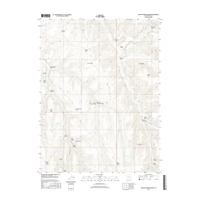
2017 Map of Tom Patterson Canyon
USGS Topo · Published 2017About this map
McCook Ridge and Rat Hole Ridge define this high-elevation landscape in Uintah County, where a complex network of deep canyons and seasonal springs provided the essential geography for ranching and travel. Named features like Moccasin Trail Canyon and Moonshine Canyon suggest a history of early passage and frontier activity. The map reveals a reliance on vital water sources such as Sweet Water Spring, Gorge Spring, and Black Horse Spring scattered throughout the drainage systems of Bitter Cr. Human movement through this steep terrain is anchored by Railroad Canyon Rd, which snakes through the southern reaches near Railroad Canyon. This 2017 survey serves as a detailed record of topographical landmarks, including numerous family-named features like Tom Patterson Point and Tom Patterson Ridge.
Find a feature on this map
35 named features on this map. Tap any name to fly to it.
Don’t see what you’re looking for? This feature index may not catch every label — zoom into the map to look around manually.
Map Details
Editions of this 2017 Tom Patterson Canyon Map
This is the sole edition of this map. No revisions or reprints were ever made.
Other maps of this area

1885 · East Tavaputs
USGS Topo · 1:250,000

1956 · Grand Junction
USGS Topo · 1:250,000

1959 · Grand Junction
USGS Topo · 1:250,000

1960 · Grand Junction
USGS Topo · 1:250,000

1962 · Grand Junction
USGS Topo · 1:250,000

1964 · Grand Junction
USGS Topo · 1:250,000

1965 · Grand Junction
USGS Topo · 1:250,000

1966 · Seep Canyon
USGS Topo · 1:24,000

1966 · Tom Patterson Canyon
USGS Topo · 1:24,000
1966 · Rat Hole Ridge
USGS Topo · 1:24,000