
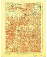
1916 Map of Tomah
USGS Topo · Published 1916About this map
The Sparta Target Range Military Reservation dominates the northwest corner of this 1914 survey, a significant landscape feature in a region otherwise defined by intricate valley systems. Settlement patterns follow the topography, with rail hubs like Norwalk and Wilton positioned along the Chicago and Northwestern line, while Tomah anchors the northeast where the Chicago Milwaukee and St Paul railroad passes through. This era shows a dense network of local infrastructure, including numerous numbered rural schools and the Town Hall in Adrian.
Find a feature on this map
73 named features on this map. Tap any name to fly to it.
Don’t see what you’re looking for? This feature index may not catch every label — zoom into the map to look around manually.
Map Details
Editions of this 1916 Tomah Map
2 editions found
Other maps of this area

1909 · Sparta
USGS Topo · 1:62,500

1919 · Kendall
USGS Topo · 1:62,500

1921 · Kendall
USGS Topo · 1:62,500

1923 · Viroqua
USGS Topo · 1:62,500

1926 · Viroqua
USGS Topo · 1:62,500

1926 · La Farge
USGS Topo · 1:62,500

1927 · Hillsboro
USGS Topo · 1:62,500

1928 · Melrose
USGS Topo · 1:48,000

1947 · Millston
USGS Topo · 1:62,500

1947 · Sparta
USGS Topo · 1:62,500