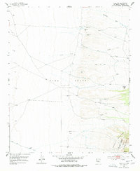
1952 Map of Tome NE
USGS Topo · Published 1977About this map
The vast expanse of the Tome Grant defines this landscape in the early 1950s, reaching from the open plains toward the rising elevations of the Manzano Mountains in the southeast. Water remains the critical factor for survival and land use in this arid New Mexico territory, evidenced by a series of named springs such as Ojo Alamo, Ojo Huelos, Ojo Lemita, and Ojo Jediondilla. These water sources, along with several scattered Windmill locations, indicate a ranching economy where livestock management depends on these specific, isolated points of relief.
Find a feature on this map
18 named features on this map. Tap any name to fly to it.
Don’t see what you’re looking for? This feature index may not catch every label — zoom into the map to look around manually.
Map Details
Editions of this 1952 Tome NE Map
4 editions found
Other maps of this area

1917 · Estancia
USGS Topo · 1:125,000

1952 · Tome SE
USGS Topo · 1:24,000

1952 · Tome NE
USGS Topo · 1:24,000

1952 · Turn
USGS Topo · 1:24,000

1952 · Tome
USGS Topo · 1:24,000

1952 · Los Lunas SE
USGS Topo · 1:24,000

1952 · Los Lunas
USGS Topo · 1:24,000

1954 · Bosque Peak
USGS Topo · 1:24,000

1954 · Capilla Peak
USGS Topo · 1:24,000

1954 · Torreon
USGS Topo · 1:62,500