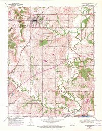
1951 Map of Tonganoxie
USGS Topo · Published 1971About this map
Tonganoxie serves as the focal point of this rural Kansas landscape, where the town's grid meets the converging flows of Tonganoxie Creek and the meandering Stranger Creek. The 1970s updates, visible as purple revisions, highlight the introduction of the Kansas Turnpike slicing diagonally across the terrain, a stark modern contrast to the established agricultural patterns of the early mid-century. This map preserves a dense network of local education and memorial sites, from Maple Grove Cem to the numerous rural schoolhouses like Walnut Sch and Honey Valley Sch that once anchored these townships. To the south, the village of Linwood sits near the banks of the Kansas River, where the Union Pacific railroad tracks follow the river's path, marking the historic transportation corridor of Leavenworth County.
Find a feature on this map
32 named features on this map. Tap any name to fly to it.
Don’t see what you’re looking for? This feature index may not catch every label — zoom into the map to look around manually.
Map Details
Editions of this 1951 Tonganoxie Map
4 editions found
Other maps of this area

1885 · Lawrence
USGS Topo · 1:125,000

1886 · Oskaloosa
USGS Topo · 1:125,000

1887 · Olathe
USGS Topo · 1:125,000

1888 · Oskaloosa
USGS Topo · 1:125,000

1889 · Lawrence
USGS Topo · 1:125,000

1890 · Kansas City
USGS Topo · 1:125,000

1893 · Olathe
USGS Topo · 1:125,000

1894 · Kansas City
USGS Topo · 1:125,000

1894 · Oskaloosa
USGS Topo · 1:125,000

1934 · Bonner Springs
USGS Topo · 1:48,000