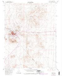
1960 Map of Tonopah
USGS Topo · Published 1982About this map
Tonopah is defined by its deep connection to the silver mining industry, centered on the rugged peaks of the San Antonio Mountains at the turn of the 1960s. The map reveals an intricate network of claims and workings that surround the town, including legacy sites such as the Belle of Tonopah, Montana Tonopah, and Mizpah Hill. Local infrastructure is concentrated on the slopes of Mt Oddie and Ararat Mtn, where the town's civic core—comprising the Hospital, Tonopah Sch, and several radio towers—clings to the steep terrain. To the east, the landscape transitions into the broad expanse of Ralston Valley, while an aqueduct and Ice Plant Spring trace the essential water routes through this arid Nevada landscape. The boundary between Nye and Esmeralda counties cuts directly through the area, marking the administrative heart of this historic mining district.
Find a feature on this map
51 named features on this map. Tap any name to fly to it.
Don’t see what you’re looking for? This feature index may not catch every label — zoom into the map to look around manually.
Map Details
Editions of this 1960 Tonopah Map
4 editions found
Other maps of this area

1907 · Tonopah
USGS Topo · 1:250,000

1908 · Lida
USGS Topo · 1:250,000

1908 · Tonopah
USGS Topo · 1:250,000

1913 · Lida
USGS Topo · 1:250,000

1945 · Goldfield
USGS Topo · 1:125,000

1952 · Mud Lake
USGS Topo · 1:62,500

1954 · Goldfield
USGS Topo · 1:250,000

1955 · Goldfield
USGS Topo · 1:250,000

1956 · Tonopah
USGS Topo · 1:250,000

1958 · Goldfield
USGS Topo · 1:250,000