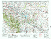
1954 Map of Torrington
USGS Topo · Published 1984About this map
North Platte River waters dominate the eastern plains and central basins of Wyoming in this mid-century survey, shaping a landscape of irrigation canals and historic river crossings. Significant water infrastructure is visible, including the Glendo Reservoir and Guernsey Reservoir, which feed systems like the Interstate Canal and Fort Laramie Canal to support the agricultural settlements of Torrington, Lingle, and Yoder. To the west, the topography rises sharply into the Laramie Mountains and the Medicine Bow National Forest, where peaks like Buffalo Peak and Saddleback Mountain stand in contrast to the northern Sand Hills. Historical transit is a central theme, as the map records the paths of the Burlington Northern and Chicago and North Western railroads alongside the landmark Register Cliff, a key point on the old emigrant trails. Smaller siding locations such as Irvine Siding and Barnes Siding mark the era's rail-dependent rural economy.
Find a feature on this map
93 named features on this map. Tap any name to fly to it.
Don’t see what you’re looking for? This feature index may not catch every label — zoom into the map to look around manually.
Map Details
Editions of this 1954 Torrington Map
4 editions found

Other maps of this area

1896 · Patrick
USGS Topo · 1:125,000

1896 · Hartville
USGS Topo · 1:125,000

1898 · Scotts Bluff
USGS Topo · 1:125,000

1899 · Goshen Hole
USGS Topo · 1:125,000

1899 · Whistle Creek
USGS Topo · 1:125,000

1901 · Hartville
USGS Topo · 1:125,000

1902 · Edgemont
USGS Topo · 1:125,000

1915 · Como Ridge
USGS Topo · 1:48,000

1918 · Como Ridge
USGS Topo · 1:62,500

1943 · Esterbrook
USGS Topo · 1:62,500