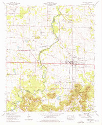
1974 Map of Town Creek
USGS Topo · Published 1975About this map
Town Creek serves as the central hub of this north Alabama landscape, situated where the Southern Railway bisects the county line between Colbert and Lawrence counties. The 1970s terrain is defined by a dense network of family cemeteries and rural congregations, including Madding Cem, Dillahunty Cem, and St James Memorial Ch. Notable landmarks like Winston Quarters and Hazlewood High School anchor the local community. To the south, the topography shifts from the agricultural flats of Tupelo Bottoms toward the elevation of Round Mountain and Black Ground Mountain. This survey illustrates a post-war rural economy transitioning into a more modern infrastructure, with Town Creek winding through the center, feeding into the Big Bend as it moves toward the Tennessee River valley.
Find a feature on this map
77 named features on this map. Tap any name to fly to it.
Don’t see what you’re looking for? This feature index may not catch every label — zoom into the map to look around manually.
Map Details
Editions of this 1974 Town Creek Map
2 editions found
Other maps of this area

1914 · Rogersville
USGS Topo · 1:48,000

1914 · Muscle Shoals
USGS Topo · 1:48,000

1916 · Muscle Shoals
USGS Topo · 1:62,500

1916 · Rogersville
USGS Topo · 1:62,500

1924 · Tuscumbia
USGS Topo · 1:48,000

1926 · Tuscumbia
USGS Topo · 1:62,500

1936 · Thorntontown
USGS Topo · 1:24,000

1936 · Courtland
USGS Topo · 1:24,000

1936 · Wheeler Dam
USGS Topo · 1:24,000

1936 · Town Creek
USGS Topo · 1:24,000