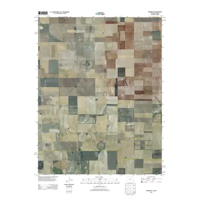
2013 Map of Towner SE
USGS Topo · Published 2013About this map
The High Plains landscape of the Colorado-Kansas border is defined by the intersection of four counties and the intermittent flow of Wild Horse Cr. This 2013 survey provides a clear view of the rural section lines and township boundaries where Kiowa, Prowers, and Greeley counties meet at the state boundary. The terrain is marked by the rectilinear grid of county roads, such as Co Road G and Co Road WW, which follow the Public Land Survey System divisions. The path of Wild Horse Cr cuts a rare diagonal across these grids in the southwestern portion of the sheet, while State Line Rd provides a physical boundary between the two states. The lack of concentrated settlements highlights the agricultural and ranching character of this border region during the early 21st century.
Find a feature on this map
26 named features on this map. Tap any name to fly to it.
Don’t see what you’re looking for? This feature index may not catch every label — zoom into the map to look around manually.
Map Details
Editions of this 2013 Towner SE Map
This is the sole edition of this map. No revisions or reprints were ever made.
Other maps of this area

1890 · Granada
USGS Topo · 1:125,000

1892 · Granada
USGS Topo · 1:125,000

1894 · Granada
USGS Topo · 1:125,000

1954 · Lamar
USGS Topo · 1:250,000

1955 · Holly NE
USGS Topo · 1:24,000
1955 · Holly NW
USGS Topo · 1:24,000

1955 · Scott City
USGS Topo · 1:250,000

1958 · Lamar
USGS Topo · 1:250,000

1958 · Scott City
USGS Topo · 1:250,000
1966 · Tribune 3 NW
USGS Topo · 1:24,000