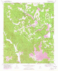
1949 Map of Townley
USGS Topo · Published 1981About this map
Townley and the surrounding mining landscape of Walker County define this 1949 survey, which highlights a region heavily shaped by mineral extraction and the St Louis San Francisco RR. The map illustrates the expansion of extensive Strip Mine operations that cut through the topography around Lost Creek and Cane Creek. These industrial features contrast with the established rural infrastructure of the mid-twentieth century, including numerous family and community landmarks such as New Hope Ch, Union Hill Church, and Beech Grove Church. The presence of the Palmer Sch and several small cemeteries like Manasco Cem and Easy Cem provides a detailed look at the social fabric of these small settlements before later industrial and highway developments further altered the terrain. The corridor along the Bankhead Highway serves as a primary artery connecting remote communities like Cedrum and Pocahontas.
Find a feature on this map
61 named features on this map. Tap any name to fly to it.
Don’t see what you’re looking for? This feature index may not catch every label — zoom into the map to look around manually.
Map Details
Editions of this 1949 Townley Map
3 editions found
Other maps of this area

1893 · Jasper
USGS Topo · 1:125,000

1949 · Parrish
USGS Topo · 1:24,000

1949 · Townley
USGS Topo · 1:24,000

1949 · Jasper
USGS Topo · 1:24,000

1949 · Oakman
USGS Topo · 1:24,000

1949 · Manchester
USGS Topo · 1:24,000

1949 · Nauvoo
USGS Topo · 1:24,000

1950 · Nauvoo
USGS Topo · 1:24,000

1950 · Manchester
USGS Topo · 1:24,000

1951 · Jasper
USGS Topo · 1:24,000