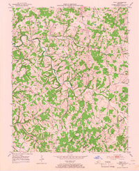
1953 Map of Tracy
USGS Topo · Published 1966About this map
Peter Creek and its many winding tributaries define the rural landscape of southern Barren County in the early 1950s. This agricultural territory is dotted with numerous country schools and churches that served as community anchors, such as the Antioch Sch and Pleasant Point Ch. The settlement pattern follows the drainage of Caney Fork and Dry Fork, where small clusters of homes at Tracy and Etoile represent the primary centers of local commerce. Family history is deeply rooted here, evidenced by numerous small burial grounds including the Bradshaw Cem and Mosby Cem. The map reveals a transition into Monroe County at its southern edge, where Union Church sits near the boundary line. A single Gas Well suggests the early reach of natural resource extraction into this otherwise quiet farming region.
Find a feature on this map
40 named features on this map. Tap any name to fly to it.
Don’t see what you’re looking for? This feature index may not catch every label — zoom into the map to look around manually.
Map Details
Editions of this 1953 Tracy Map
2 editions found
Other maps of this area

1926 · Scottsville
USGS Topo · 1:62,500

1931 · Lafayette
USGS Topo · 1:62,500

1931 · Red Boiling Springs
USGS Topo · 1:62,500

1953 · Tracy
USGS Topo · 1:24,000

1953 · Temple Hill
USGS Topo · 1:24,000

1953 · Glasgow South
USGS Topo · 1:24,000

1953 · Freedom
USGS Topo · 1:24,000

1954 · Austin
USGS Topo · 1:24,000

1954 · Fountain Run
USGS Topo · 1:24,000

1954 · Gamaliel
USGS Topo · 1:24,000